|
|
From San Francisco to Mammoth Lake, with a night stop in Yosemite-Mariposa
(This page and the next contain the least interesting
pictures of the flight, because I had some trouble piloting AND shooting nice picture for
your pleasure at the same time. After some time, I learned to do this and the last pictures of the flight are really breathtaking.) Spectacular pictures await you at the end of this
trip.
Don't leave this site without checking and
The day I left the San Francisco Bay Area from San Carlos, I had to fly on top of some
broken cumulus and, as every pilot can appreciate, I got disoriented. I was lucky enough to be
able to find a hole in the clouds and I descended so low through it that I could read the name of an airport on a
hangar! It may have looked like fun but I was really scared. From that minute I began a navigation
method that I have used ever since. I simply wrote a little cross on the map over my
position every 5 minutes or so with the actual hour in four digits beside it. This is
quite different from what you learn in books, but it is really the best way I know to avoid getting lost. |
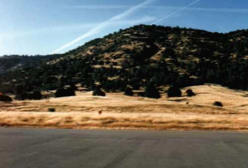
This is the view of the runway of the Mariposa-Yosemite airport from my one-person tent.
I spent a short night of little sleep there, but the people were really helpful.
The woman who runs the airport office helped me find water and the sheriff came to check that I wasn't in any danger sleeping on the airport. I tried to cross an enormous
field to reach the only restaurant around, but when I was in the middle of it, I suddenly
understood why there was barbed wire around: young bulls were in the field. Suddenly
they discovered a new game to test their nascent virility and they began to run after me
with their horns low to the ground. I ran as fast as I could and somehow managed to escape
unharmed. |
| A ranger at Mariposa explained to me, as he was tying his plane down, how I could reach
the other side of the Sierra Nevadas the next morning. There was a pass in the mountains called the Mammoth Path not far from there, and if I climbed to 10,000' I could reach the other side safely, provided
there was no cloud and no wind. I woke up at 5 am the next day and prepared the plane. I
soon took off in the cool, calm morning air and reached 10,000' rather quickly. I
entered the Mammoth Path, praying that my engine wouldn't stop at that moment. It didn't, and
soon I heard the disembodied voice of the AWOS (Automated Weather Observation
Station) telling me the conditions on the other side. On hearing that voice and
seeing what the Sierra Nevadas looked like, I thought I was in Niourk.
The gigantic valley that began to appear slowly is probably the most impressive landscape
I have ever seen (and remember, I come from Switzerland). Just image a huge desert
valley about 6000' above sea level, set between two mountain ranges that stretch as far as the eye can see. The combination is breathtaking. |
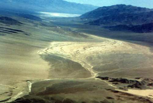
The awesome desolation of the Sierra slowly unfolded...
|
Go to the clickable map to see the other legs and pictures of the
trip, or just use the arrows on your left if your connection is slow. Or directly proceed
to the  |
|
 |